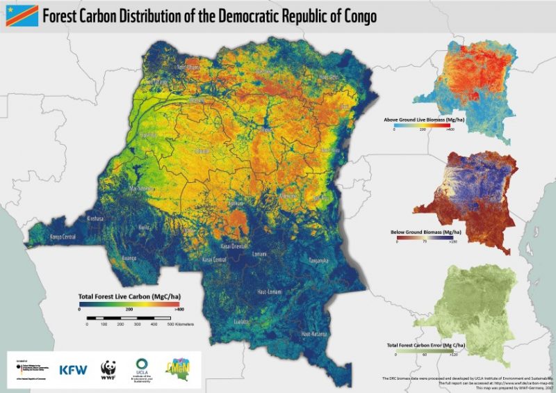
national scale biomass for the DRC
The Carbon Map & Model project was a 5 year initiative funded by the International Climate Initiative (IKI) of the Federal Ministry of the Environment, Conservation, and Nuclear Security, with implementation by the German Development Bank KfW; which produced a national scale biomass map for the entire forest coverage of the Democratic Republic of Congo (DRC) along with feasibility assessments of different forest protection measures within a framework of a REDD+ model project. This national map is the first of its kind in Africa, developed to support greenhouse gas emissions reduction and finance sustainable development in the largest forest tract in Africa.
In collaboration with the University of California Los Angeles (UCLA), and the Jet Propulsion Laboratory of NASA Dr. Sassan Saatchi, a laser system (LiDAR) mounted on an airplane was used to collect a series of 217 plots of tropical forest, via a stratified random sampling strategy. Calibrated by field-based inventories, over 400,000 hectares of detailed imagery and forest structure information were used to create allometric models to estimate above ground forest biomass (AGB), which were then extrapolated to create the first, national scale, spatially explicity map of forest carbon for more than 2 million sq. km of land area.
 The results were published in a final report, and peer-reviewed Nature Scientific Reports.
View the data and story map on GLOBIL.
The results were published in a final report, and peer-reviewed Nature Scientific Reports.
View the data and story map on GLOBIL.
Are you interested in cutting edge methods for mapping forest biomass? maybe even in mangroves? Drop us a line!