In February, 2019, WWF-Columbia invited me to Cali, Colombia to show the national government and regional partners howto do accurate and almost entirely automated mangrove mapping with Google Earth Engine. I provided a basic introduction to image pre-processing and compositing, water masking and automated mangrove classification to a very positive, enthusiastic audience. Currently, each region has its own approach for mapping mangroves – but by using a cloud platform together, we can develop consistent, nation wide projects collaboratively.
The mangrove mapping methods are constantly being improved. The workflow now includes cloud-free synthetic aperture radar from the Sentinel-1 and ALOS satellites, as well as Sentinel-2 data from the European Copernicus program, meaning we can map mangroves almost monthly at 10m resolution.
We have also expanded the WWF Mangrove app to a Neo Tropical version and surveyed 20 hectares of mangroves near Buenaventura with a Mavic Pro drone – meaning in less than a day’s work we can study mangrove species and condition. We are now a few steps closer to developing a national mangrove strategy for Colombia, which has the 3rd highest mangrove canopy in the world!
Here is the story map that outlines the methods and approach:
and here is are the mosaic of the beach and mangrove area we surveyed with a drone.
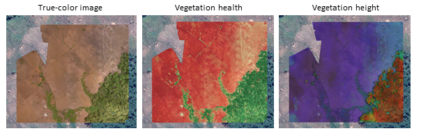
and with the latest application of DroneDeploy, we can process drone imagery quickly in the cloud, and obtain canopy height and vegetation health indicators in a matter of minutes – all with a drone you can buy on Amazon. See an example here:

Do you want to map mangroves automatically, in the cloud at any scale? Get in touch!