In February, 2019, WWF-Columbia invited me to Cali, Colombia to show the national government and regional partners howto do accurate and almost entirely automated mangrove mapping with Google Earth Engine. I provided a basic introduction to image pre-processing and compositing, water masking and automated mangrove classification to a very positive, enthusiastic audience. Currently, each region has its own approach for mapping mangroves - but by using a cloud platform together, we can develop consistent, nation wide projects collaboratively.
The mangrove mapping methods are constantly being improved. The workflow now includes cloud-free synthetic aperture radar from the Sentinel-1 and ALOS satellites, as well as Sentinel-2 data from the European Copernicus program, meaning we can map mangroves almost monthly at 10m resolution.
We have also expanded the WWF Mangrove app to a Neo Tropical version and surveyed 20 hectares of mangroves near Buenaventura with a Mavic Pro drone - meaning in less than a day's work we can study mangrove species and condition. We are now a few steps closer to developing a national mangrove strategy for Colombia, which has the 3rd highest mangrove canopy in the world!
Here is the story map that outlines the methods and approach:
 and here is are the mosaic of the beach and mangrove area we surveyed with a drone.
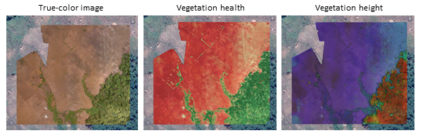
and with the latest application of DroneDeploy, we can process drone imagery quickly in the cloud, and obtain canopy height and vegetation health indicators in a matter of minutes - all with a drone you can buy on Amazon. See an example here:
and here is are the mosaic of the beach and mangrove area we surveyed with a drone.
and with the latest application of DroneDeploy, we can process drone imagery quickly in the cloud, and obtain canopy height and vegetation health indicators in a matter of minutes - all with a drone you can buy on Amazon. See an example here:

 Do you want to map mangroves automatically, in the cloud at any scale? Get in touch!
and here is are the mosaic of the beach and mangrove area we surveyed with a drone.
and with the latest application of DroneDeploy, we can process drone imagery quickly in the cloud, and obtain canopy height and vegetation health indicators in a matter of minutes - all with a drone you can buy on Amazon. See an example here:
Do you want to map mangroves automatically, in the cloud at any scale? Get in touch! Deforestation Fronts Report 2020
13 January 2021
A new report highlighting the world's most important deforestation fronts
WWF India Tech webinar in the spotlight
23 October 2020
From drones to mobile apps, how tech is conserving nature...
Geo for Good Lightning talk
23 October 2020
Lightning Talk on Seascape mapping in East Africa at the Geo for Good Summit 2020
Story Map: Monitoring Natural Habitats of KAZA
14 October 2020
A new Story Map showcasing our monitoring work in KAZA.
Twitter feed is not available at the moment.